The full report on the
discovery of Cota Coca is below
Cota Coca
Reconnaissance Project
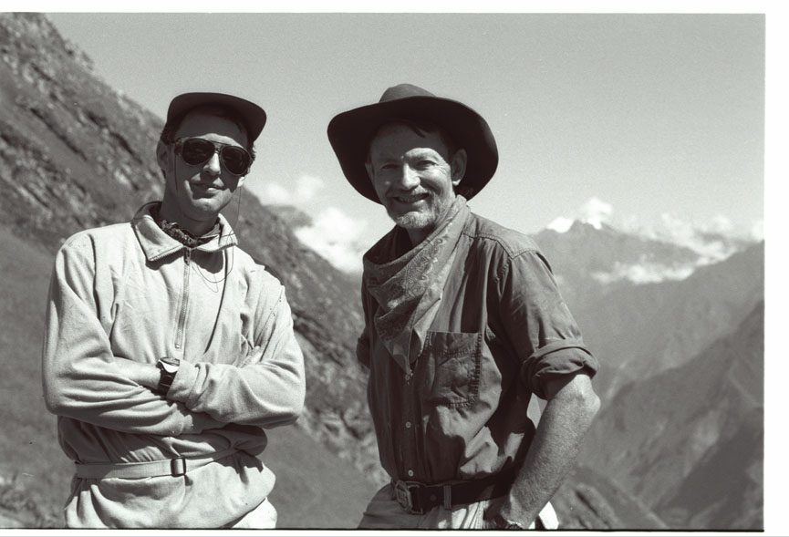
A Report by Gary Ziegler and Hugh Thomson
This reconnaissance
expedition to the Vilcabamba area of Eastern Peru was led by the American
archaeologist Gary Ziegler and the British writer and explorer Hugh
Thomson. The team included the veteran
Andean explorer, Nicholas Asheshov, who took part in the Brooks Baekeland Expedition of 1963, and the Australian explorer,
John Leivers, together with field helpers Anne Bradley, Gary Bradley and Greg Dansforth. The team
also consisted of eight mule handlers, led by Pío
Espinosa and Froilán
Muñoz.
Ziegler has
extensive knowledge of the area dating back to the 1960s when he first led
reconnaissance teams to the area, having completed his doctoral work in Inca
archaeology. He has published several
field studies of important sites.
Thomson worked with
teams from the Cusichaca Project in 1982 and has
since travelled and researched extensively in the Peruvian Vilcabamba and
written about the area: he is the author
of The White
Rock: An Exploration of the Inca
Heartland and of a critical edition of Hiram Bingham’s Lost City
of the Incas.
Ziegler and Thomson
had previously done reconnaissance work together in other areas of the
Vilcabamba. Acting on information
Ziegler had received from a local farmer on a previous trip and some preliminary
investigation, the aim of this reconnaissance expedition was to map and clear a
previously unreported and unexamined Inca site in the lower Yanama
valley, in an area traditionally known by the name of Cota Coca.
The site proved to be
an important and substantial addition to the pattern of already known Inca
settlements in the Vilcabamba area.
Logistical support
was generously provided by Barry Walker, the
British Consul in Cuzco, and Peru based Manu Expeditions. The expedition was also greatly helped by the
support given by Mr Simon Sherwood and the Orient Express and Perurail companies.
The approach route
was from Cachora, passing across the Apurímac and
over-nighting in Choquequirao, where it was possible
to liaise with COPESCO archaeologist Percy Paz, who knows this area well.
After crossing the
pass above the Choquequirao ruins, at approximately 3100 metres, the team
descended to the Río Blanco at 1850m: it
was not possible to traverse around the lower Río Blanco valley, due to the
severe erosion of the valley at that point, so a further ascent had to be made
to a campsite at 2950m below Cerro Victoria, before being able to descend to
the small mesa at the bottom of the Yanama valley where the Cota Coca ruins are found.
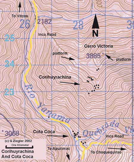
The Cota Coca site
lies at 1850m ( GPS map location: 18L 0727848-UTM 8521494) near the junction of
the Yanama and Blanco rivers.) It is on an isolated
bench or mesa some two kilometres
long, left as an eroded remnant when the Río Yanama
river cut a deep chasm near its intersection with the Río Blanco.
Map showing position of Cota
Coca
This area of the
Vilcabamba is characterised by the deep canyons which rivers such as the
Apurímac and Urubamba have made through the mountain ranges on their rapid
descent to the Amazon basin.
The valley bottom
at Cota Coca is hot and semi-tropical with a micro-climate environment created
by the deep canyon. Like the nearby Inca
site of Choquequirao, the bed rock is an assortment of metamorphic muscovite
schist and fine grained yellow quartzite. A considerable depth of alluvial
deposit swept in by river flooding and canyon breakdown covers the valley
floor. Much of this material is made up of igneous grey granite in the form of
rounded river stones that have been carried downstream.
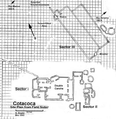
Site-plan at Cota Coca, based
on initial Field Notes
An initial
clearance showed that Cota Coca contains at least thirty stone-built
structures, including a seventy-five foot long kallanka ( meeting hall ) grouped
around a great central plaza, with some walls standing to a height of 3 metres
Construction and
architectural features are in the style typical of this part of the Vilcabamba,
derived from the construction characteristics of the local rock type. The
schist, quartzite and metamorphosed sediments comprising the southern
Vilcabamba range break along parallel molecular alignment representing the
bedding planes of compressed ancestral shale and sandstone. Unlike the granite
of Machu Picchu and the limestone/andesite of Cuzco,
this material can only be worked into square, flat or rectangular shapes.
This geological
feature was previously identified by Ziegler in his work at Choquequirao. It may be one reason why Hiram Bingham and
others long discounted Choquequirao as having inferior construction and
architecture to other monumental sites. Bingham did not realize that the
fragile metamorphic rock of the Apurímac region would not permit the fine
polygonal shapes and massive blocks commonly associated with monumental and
high status Inca architecture – nor that the stonework was probably plastered
The best
construction at Cota Coca consists of shaped, fitted rectangular blocks of
quartzite seen in the construction of the doorways, windows and corners. Walls are made either of coursed
stone, or of fitted and mortared smaller blocks of mixed schist and quartzite
fieldstone. As at Choquequirao, most
structures were probably plastered over with a tan-coloured clay, giving the
appearance of a `Santa Fe’ pueblo house.
Windows
and entrance ways are almost rectangular and reminiscent of many structures at Choquequirao. Niches are
not evident.
Outside
the central area are more well made rectangular houses: there are also some low, round auxiliary
structures that may have been wooden-sided above a stone-walled base, as there
was no evidence of rubble.
Beyond
the main sector are two large walled enclosures, (c. 175' x 100'), possibly used as holding pens for passing
llama trains: Cota Coca lies along the
route from Vitcos to Choquequirao and across the
Apurímac to the Capac-nan,
the ‘royal road’, which runs across Peru.
Because of severe erosion in the lower Yanama
valley, this route has fallen into disuse and sections have been lost.
Site-plan at Cota Coca, based
on initial Field Notes
Sector I: The main sector
consists of a large walled cancha (compound ) enclosing a central plaza bordered on
three sides by unusual buildings and a smaller cancha with two well constructed
houses facing each other in Inca style.
The group is arranged in classic Inca cancha arrangement [cf Moseley p75].
The team divided
the site into a further four sectors in addition to this main group:
Sector I- Main Cancha Group
Sector II- West group
Sector III- Corrals and Walls
Sector IV- South Group
Sector V- Canal House and Canal
Sector II was made up of 12 low-walled, one metre high structures up to
10 metres in length that may have supported wooden-sided houses. Some of these were rectangular, while some
were oval. They are similar to
structures at Pincha Unuyoc
(the site near Choquequirao first reported by Thomson in a reconnaissance
project of 1982). All would have had
thatched grass roofs. Each has a single entrance way made from coursed,
selected and squared quartzite blocks.
Sector III is contained by the long walls that begin some 50 metres to
the south of the main cancha
and run parallel and near the river course along a north-south axis. A stepped round wall enclosing several boulders
at the far south end of one of the enclosures appears to be a huaca or small
shrine.
Sector IV is an area of round low
walled structures made from large rounded river stone, usually some 4-7 metre
in diameter. This group may have been pre-Inca or be have been for imported
worker (mitamayos)
satellite housing away from the main group. We were not able to clear and
examine all of these so the exact number is unknown.
Sector V is a single rectangular house perched on a small rise
overlooking the river and a wide depression running for some distance that we
believe to be a acequia
or water canal now left dry by the eroding river cut below. A long stone wall
runs at a slight angle to the depression. This sector lies to the north of the
main group and approximately 300 metres up river.
A main Inca road appears
to have passed near the site and down the Yanama
valley, which has experienced much flooding and lowering of the water channel
since Inca times.
The Incas at the
apex of their expansion in the early 16th century maintained a complex system
of all weather roads and secondary branch routes estimated at 30,000-40,000
kilometres [cf Hyslop 1984,
also Moseley, The Incas and Their
Ancestors,10]. The main roads were up to
4.5 metres wide where permitted by the terrain, paved with flat, fitted
stones and retained by stone walls. Raised causeways crossed wet or boggy areas
and stepped stairways with switch backs carried official travellers over
mountain passes.
Several principal
Inca roadways pass into and through Vilcabamba connecting the various sites through
a network of roads and secondary pathways [cf Lee
2000, Ziegler 2001, Hyslop 1984, Kendall 1984]. A number of factors make following these
routes difficult: dense forest, thick undergrowth vegetation and numerous
landslides which have truncated and covered the way.
The Yanama valley road is likely to be the continuation of the Vitcos-Choquequirao route coming over the Choquetecarpo Pass, bound for a crossing over the Apurímac.
The section below the pass measures up to 4.5 metres wide in open areas and
crosses over steep areas, with some retaining walls more than 6 metres high. An
important individual contribution by John Leivers led to the discovery of a
further Inca road and a number of accompanying structures beginning up towards
Choquequirao, as a branching route from the main Inca path not far from the
confluence of the Yanama and Blanco rivers.
It is unlikely that
the site was visited or known of following the fall of the last Sapa Inca, Tupac Amaru, in 1572.
However one early explorer, the Comte de Sartiges,
passed this way to reach Choquequirao in 1834.
He refers in his writing to the lower Yanama
Valley being “known as Cotacoca” although he makes no
mention of ruins. The dense forestation
means that it would be easy to miss them and he seems to have kept to the
riverbank. He commented at the time that
he “thought it unlikely anyone could have inhabited this narrow valley because
of the numerous and voracious mosquitoes that have taken possession of it. It
was impossible to breathe, drink or eat without absorbing quantities of these
insufferable creatures.” [Sartiges 1950]
Later explorers
almost always approached Choquequirao from the more accessible access point of Cachora and the Apurímac crossing on the other side of that
ruin. Indeed it is unlikely that any of
the early visitors to Choquequirao found Cota Coca. Although only a few air miles distant, they
are a world away across a deep canyon with connecting Inca routes long lost and
severed. The new site of Cota Coca has never been documented, reported or known
to the outside world until this present investigation.
Time and resources
were limited by the extreme conditions, physical exhaustion and difficult
access, so any initial interpretations are preliminary and await excavation.
The main group of
buildings (Sector I) containing the large meeting hall and a smaller compound
may have served as overnight lodgings for high status Inca travellers on what
would have been an important route, particularly in the neo-Inca period when
communication from Vitcos towards the Apurímac would
have been of paramount importance to the exiled Inca court.
In general, the lay
out is functional rather than ceremonial.
Some buildings in the outlying Sectors may have housed resident
administrators, quipucamayos
(record keepers) workers, servants and the usual assortment of retainers living
and working about such an outpost. The number of closely grouped round and oval
structures may have been a combination of resident mitamayo ( imported workers)
lodging and store houses for corn and other commodities.
As with most such
sites, the surrounding area would have been cultivated and may have also been a
coca growing region which the climate and altitude would permit (it is similar
in altitude and situation to the Picchu valley, which we know produced coca, [cf Rowe 87] and the area may also have been known as Cota
Coca because of this).
The flat and sometimes
walled fields along the upriver approach to the site and the possible remains
of a water canal suggest that tropical fruit may have been grown as well.
However the complex is not an agricultural settlement.
The relative
altitudes and positions of this site and the recently reported
Corihuayrachina/Victoria site which lies above it would suggest that they
formed part of a vertically integrated agricultural zone, with the Cota Coca
site as the main administrative centre and the much smaller Corihuayrachina (at
an altitude band above 3000m) providing high-altitude crops and possibly a
ceremonial platform.
Cota Coca appears
to have been an administrative and storage/supply centre on the main road
between the interior of Vilcabamba and the Apurímac region beyond.
The surmise is that it may have been initially
built, abandoned and utilised at the same times as Choquequirao and
Corihuayrachina/Victoria as part of a network of interconnected, economically
supportive sites. The pottery and archaeological record at these sites
indicates early transitional (Kilke) occupation
followed by imperial Inca (type A and B) and then neo-Inca.
The hope is to
undertake or support a further more detailed investigation including excavation
of Cota Coca that will produce more data before the site is disturbed or
looted. Currently, in co-ordination with
the Victoria/Corihuayrachina project, Froilán Muños and Valentín Saca are guarding the approaches to both sites with the
authorisation of the Peruvian I.N.C.
Angrand, Léonce in Ernest Desjardins: Le Pérou Avant La Conquete Espagnole (Paris 1858)
Bingham, Hiram: Across South America (New York 1911)
Inca Land (Boston 1922)
Machu Picchu, a Citadel of the Incas (New Haven 1930) []
Lost City of the Incas (New York 1948)
‘The Ruins of Choquequirrau’ (American Anthropologist 12 1911)
‘Vitcos the Lost Inca Capital’ (Proceedings Of American
Antiquarian Society April 1912)
‘A Search for the
lost Inca Capital’ (Harpers magazine 1912)
‘In the Wonderland
of Peru’ (National Geographic April 1913)
‘The Ruins of
Espíritu Pampa’ (American Anthropologist 16
1914)
‘Along the
Uncharted Pampaconas’ (Harpers magazine August 1914)
‘The Story of Machu
Picchu’ (National Geographic Feb 1915
‘Further
Explorations in the Land of the Incas’ (National Geographic May 1916)
Bauer, Brian: The Development of the Inca State, University of Texas Press,
Austin 1992
Beauclerk John: ‘La Cordillera Vilcabamba, Ultimo Refugio de
los Incas’ (Boletín de Lima, Nos 4 & 5, Lima, March
1980)
Burger, Richard L. and Lucy Salazar-Burger:
‘Machu Picchu Rediscovered: The Royal
Estate in the Cloud Forest’ (Discovery 24 1993)
Calancha, Antonio de la: Crónica
moralizada del orden de San Agustín en el Perú, Barcelona, 1639
Cobo, Bernabe: History of the Inca Empire 1633,
translated by Roland Hamilton, University of Texas Press, Austin, 1983
Eaton, George F: The Collection of Osteological Material from
Machu Picchu (Memoirs of the Connecticut Academy of Arts and Sciences,
Boston 1916)
Fejos, Paul: Archaeological
Explorations in the Cordillera Vilcabamba Peru, Viking Fund, Num.3, New
York, 1944
Frost, Peter: Exploring Cusco, 5th Edition: Nuevas Imagenes, Lima 1999
Frost, Peter and Bartle,
Jim: Machu Picchu Historical Sanctuary,
Nuevas Imagenes, Lima 1995
Hemming, John: The
Conquest of the Incas, Hartcourt Brace 1970,
revised edition British Papermac 1995
Hyslop, John: The
Inka Road System, New York, 1984
Garcilaso de la Vega, Inca: Royal Commentaries of the Incas and General History of Peru 1604,
translated by H.V. Livermore, Austin, 1987
Guchte, Maartin Van de:
‘Carving the World: Inca Monumental
Sculpture and Landscape’ University of Illinois Press, Urbana, 1990
Kendall, Ann:
‘Aspects of Inca Architecture -Description, Function and Chronology, 2 Volumes,
British Archaeological Reports, International Series 210, Oxford, 1984
Lee, Vincent: ‘Chanasuyu: The Ruins Of Inca Vilcabamba’ Sixpac Manco, Wilson, 1989
‘Choqek’iraw: Inca
Site Revealed’ South American Explorer, Vol. 51, 1998
Forgotten Vilcabamba: Final Stronghold of
the Inca, Empire
Publishing, 2000
Markham, Clements: The Incas of Peru London 1910
Moseley, Michael: The Incas And Their Ancestors, Thames
and Hudson, 1993.
Niles, Susan: The Shape of Inca History Iowa City, 1999
Protzen, Jean-Pierre: Inca Architecture and Construction at Ollantaytambo Oxford
University Press, Oxford,1993
Ocampo, Baltasar de:
Translated by C .Markham: ‘Account of the Province of Vilcabamba and a
narrative of the Execution of the Inca Tupac Amaru’ Hakluyt Society, Vol 2, Ser. 23, 203-47, Cambridge, 1907
Reinhard, Johan:
Machu Picchu-The
Sacred Center, Nuevas Imagenes, Lima 1991
Romero, Carlos A: ‘Informe sobre las ruinas de Choqquequirao’,
Revista Histórica, Órgano del Instituto Histórico del Perú, Vol
2. 1907
Romero Carlos and Horacio Urteaga:
Colección de libros y documentos
referentes a la historia del Perú, Series 1, vol
2, Lima, 1916
Rowe, John H.: ‘An
Introduction to the Archaeology of Cusco’, Papers of the Peabody Museum Vol.
27, No. 2, Harvard Press, 1994;
‘Machu Pijchu a la Luz de Documentos del Siglo
XVI’ (Kultur 4, Lima, March-April 1987)
Samanez Argumedo,
Roberto and Julio Zapata Rodriguez:
‘El Conjunto Arqueológico Inka De Choquequirao’
Andes: Revista de la Facultad de Ciencias Sociales, Sem.
94 II, Universidad Nacional de San Antonio Abad, Cusco, 1995
Sartiges Comte de:
‘Voyage dans les Republiques de l’Amérique du Sud’, written
under pseudonym of M.E de Lavandais,
in Revue de Deux Mondes
(Paris 1850).
Also translated as Dos Viajeros Franceses en el Perú
Republicano: De Sartiges- Botmiliau,
transl. Emilio
Romero (Lima 1947)
Savoy, Gene: Antisuyo, The Search for the Lost Cities of the
Amazon Simon and Schuster, New York, 1970
Titu Cusi Yupanqui: ‘Relación de la
Conquista del Perú y Hechos del Inca Manco II’ 1570
Thomson, Hugh: The White Rock: An Exploration of the Inca
Heartland, Weidenfeld & Nicolson, London 2001
Urton,Gary: At
The Crossroads of the Earth and Sky, An Adean
Cosmology, Univ. of Texas Press, Austin, 1981
White,Stuart:
‘Preliminary Site Survey of the Punkuyoq
Range, Southern Peru’, papers of the Institute of Andean Studies, number 22-23,
Berkeley, 1984, 1985
Wright, Kenneth:
`Machu Picchu: A Civil Engineering
Marvel’ ASCE press, Virginia 2000
Ziegler, Gary:
‘Machu Picchu Abandoned’ Crestone Press, 1994
‘Inca Architecture: The `T’ Groove: Symbol, Gold or Bronze?’ Crestone,
1998
‘Vilcabamba, Report from the field’ South
American Explorer, vol 57, 1999
`Beyond Machu
Picchu: Explorations and Adventures in Peru’s Remote Vilcabamba’. Crestone press, Westcliffe, 2001
Zuidema R. Tom, Inca Civilization in Cuzco, University
of Texas Press, 1991
© Gary Ziegler and Hugh Thomson 2002
2004 Afterword: Since the discovery of Cota Coca and the
writing of this report, further useful investigation has been carried out at
Cota Coca by the same National Geographic team led by Peter Frost which had
previously been working at the Corihuayrachina/Victoria site. See their recently distributed ‘Preliminary
Report of Findings: NGS Qoriwayrachina Project’.