Machu Picchu’s Observatory:
the Re-Discovery of Llactapata and
its Sun-Temple
This is a longer English version of the article that was first published
in the Revista Andina (2004, #39), with the title
‘El redescubrimiento de Llactapata, antiguo observatorio de Machu
Picchu’: the article was accompanied by
peer-reviews of the findings by R. Tom Zuidema, Jürgen
Golte, Peter Kaulicke and
Vincent Lee.
[Technical note: Those wishing to
view the report full-frame, should redirect their browser to
http://www.thomson.clara.net/llactapa.html ]
J. McKim
Malville
Department
of Astrophysical and Planetary Sciences, University of Colorado
Hugh Thomson
MA
(Cantab), FRGS
Gary Ziegler
FEC, Department
of Anthropology, Colorado College, FRGS
INTRODUCTION
Despite its
relative proximity to Machu Picchu, Llactapata is a site that has been very
little investigated since its first reporting by Hiram Bingham in 1912.
In May 2003 a thorough
survey of the site was made by a research team led by Hugh Thomson and Gary
Ziegler, accompanied by Kim Malville, Professor Emeritus of The University of
Colorado. The expedition was supported and approved by the Royal Geographical
Society of London.
The expedition
made a systematic exploration of the ridge and mountain slope of Llactapata,
which lies on the western side of the Aobamba
drainage facing Machu Picchu.[1]
A primary
objective was to study what may be called ‘Hiram Bingham's Llactapata group’,
which it appeared had not properly been relocated since his initial reporting
of the site in 1912.
Another objective
was to determine whether there were any further as yet unreported sectors of
the site.
A further
objective was to map properly for the first time the full extent of the
extended Llactapata site, with these multiple sectors, and produce detailed
plans of each sector, and interpret the relationship of Llactapata to Machu
Picchu, given recent archaeo-astronomical work there.
Field-work
established that the size and importance of Llactapata has been greatly
underestimated in the past, and that its alignment and relationship to Machu
Picchu is central to any interpretation of the site.
See map.
Chapter Headings:
2 THE INVESTIGATION OF THE SITE
4 SITE DESCRIPTIONS AND INTERPRETATION
Comparison
with the Coricancha
Sector II: Sector III: Sector IV: Sector V:
The first
published account of Llactapata was by Hiram Bingham as part of his article on
Machu Picchu for National Geographic, ‘In the Wonderland of Peru’ (Bingham
1913).
While the
clearance and excavation of Machu Picchu was taking place in 1912, Bingham had
sent various reconnaissance teams into the surrounding area to look for further
Inca sites.
A team led by his
assistant Kenneth Heald attempted to head up the Aobamba valley, but met with ‘almost insuperable
difficulty’, as ‘the jungle was so dense as to be almost impassable. There was no trail and the trees were so
large and the foliage so dense that observations were impossible even after the
trail had been cut.’ Heald’s
team were further discouraged when an arriero was almost bitten by a poisonous snake.
Bingham himself
then attempted to investigate the area and, in his own words, ‘got into the
reaches of the valley about ten days later, and found some interesting
ruins…The end of that day found us on top of a ridge between the valleys of the
Aobamba and the Salcantay.’[2]
Here Bingham
reported a site called ‘Llactapata, the ruins of an Inca castle’:
‘We found
evidence that some Inca chieftain had built his castle here and had included in
the plan ten or a dozen buildings.’
In his later re-writing
of this account for Lost City of the
Incas (1948), Bingham commented that Llactapata ‘may well have been built
by one of Manco’s captains. It was on a strategic spot.’
After mapping and
photographing the site, Bingham pressed on rapidly up the valley to the site of
Palcay which lies at the head of the Aobamba valley. He
had spent just five daylight hours there.
One might think
that Bingham would have both spent more time examining the site, but he was
handicapped in that he had a most unwilling team with him: three arrieros who had been pressed into service by a local
landowner as a service to Bingham and who seem to have caused him considerable
difficulty. His published account spends
far more time lamenting their deficiencies than describing the ruins
themselves. Later in the same journey
they eventually deserted him.
Bingham’s
decision to move on rapidly is also of a piece with his previous actions when
he first saw Machu Picchu, in 1911: again he initially spent just a few hours
at the site before heading on rapidly to his next objective. Only later did he send a team back to clear
the site. A certain impatience was
characteristic of the man.
In this case he
clearly decided that the difficulties of returning to Llactapata for further investigation
were prohibitive, although he seems to have regretted this, commenting:
‘It would be
interesting to excavate for three or four weeks and get sufficient evidence in
the way of shreds and artefacts to show just what connection the people who built
and occupied this mountain stronghold had to the other occupants of the
valley.’ (Bingham 1913)
Unfortunately he
left few published details for anyone who might want to return to the site to
do just that. Both the map published
with the 1913 magazine article and his account are imprecise: ‘the end of that day found us on top of a
ridge between the valleys of the Aobamba and the
Salcantay’ gives little indication of where exactly he was between two long and
densely covered valleys. The same
difficult vegetation that had defeated Bingham’s assistant Heald
still characterizes the area, and without proper compass bearings or
directions, no further expeditions reported on it.
Nor did they have
much inclination to do so. Bingham’s
decidedly half-hearted and incomplete account of it would have given them
little incentive.
The slight nature
of Bingham’s account of Llactapata must be set in its literary context. The same National
Geographic report, ‘In the Wonderland of Peru’, contains the first descriptions
of Machu Picchu itself, of Vitcos and of Bingham’s
discoveries at Espíritu Pampa. Given that any one of these by themselves
would have constituted a major discovery, it is perhaps understandable that he
did not devote as much attention to Llactapata as he might otherwise have done.
For the next
seventy years (1912 – 1982), there were no published accounts of the site. In 1982 David Drew of the Cusichaca
Project, which was coordinated by Ann Kendall, went back to the area, together
with a small reconnaissance team including Hugh Thomson. Ascending directly from Suriray in the Santa
Teresa valley, they crossed over a ridge into the Aobamba
valley and found some sites in the area immediately on the Aobamba
side.
They reported one
sector of buildings (now described as Sector II) that while similar in size to
that indicated by Bingham, and in the same rough area suggested by Bingham’s
vague description, did not match his published plan of the site (Drew
1982). They also reported finding a
higher two-storey building on the ridge above (Sector V; the ‘Overlook
Building’), and 2 small groups of buildings between Sectors I and IV.
Drew commented:
‘At Llactapata,
the fact that none of the four different groups of ruins discovered on
reconnaissance match those found by Bingham would suggest that further remains
are still to be found in the montaña here and that the site is considerably larger than
Bingham first imagined.’ (Drew 1982)
Then in 1985
Johan Reinhard passed over the site of Llactapata while investigating the Inca
trail that leads northwards from Palcay along a ridge
of Mt Salcantay (Reinhard 1990). While
he did not try to investigate the main sectors of Llactapata, he reported
coming across a substantial building on the ridge-line above, at 3,037m /9,960
ft: ‘the ruins of a large structure or
series of structures that have a nice view towards Machu Picchu’. Reinhard mapped the building. He also reported that looting had taken place
at the site: ‘Some digging had been done
here, including one hole dug recently, i.e. possibly within the past year.’
From further
investigation by the recent expedition, this appears to have been part of the
overall Llactapata site and may well have functioned as a qolqa (storehouse) for the
residential / administrative sectors below.
It is described as Sector IV of the overall site.
In 2002, Hugh
Thomson went to consult the unpublished journals of Hiram Bingham, which are
held at the Sterling Memorial Library at Yale University, and the collection of
unpublished photographs held on card index by the Peabody Museum.
He found that
Bingham had left a more detailed record of his investigations at Llactapata
than had ever been published.
Bingham’s
handwritten journal records that on August 1st 1912 he left the hacienda of Huadquiña at 7.30 in the morning and arrived at ‘Surirai’ at 9.00.
The modern hamlet of Suriray lies in the Santa Teresa (Salcantay)
valley, so Bingham had decided to approach the Aobamba
/ Santa Teresa ridge from that side, after Heald’s
difficulties in the Aobamba.
At Suriray he
scribbled hastily in his notebook: ‘men here speak of ruins: Llactapata ruins; Cochapata
- laguna; Mishihuaunca – lugar; Palcai – old pueblo;
Pampacahuana – best ruins of all.’
By 9.30 he had reached
a hut 600 ft above Suriray, noting that ‘quite a little coffee’ was being grown
in the small holdings he passed.
By 12.00, after a
‘hard climb’, he reached a clearing at the top of the ridge and met Marcello Añanca ‘who lives at Llactapata’. (There is still a small holding on the top of
the ridge today, near Sector V). By
12.35, presumably having descended over the ridge, he saw the ruins which ‘lie
at 9100 ft, i.e. 1100 ft higher than MP [Machu Picchu]’.
He remarked on
‘the wonderful view’ and that the snow peak of Salcantay was visible.
The photographic
evidence supplements the details left in his journal (see Thomson 2002 for full
discussion of Bingham’s use of the camera).
Bingham published just one photograph of Llactapata in his original National Geographic article ‘In the
Wonderland of Peru’ (Bingham 1913), and none subsequently. However the Peabody Museum has a full archive
of all the photographs taken by the Yale Expeditions, and these include six
unpublished prints of the Llactapata site:
The first picture
Bingham took (#2850), at 1.00 on August 1912, was of the ‘wonderful view’ he
had mentioned in his journal ‘looking towards Machu Picchu and the Torontoy massif’.
Clearly the unusual sighting of Machu Picchu impressed him more at first
that the actual ruins themselves, as it did for later visitors (Thomson
2001). Bingham had just come from Machu
Picchu and the careful sight-line positioning of his newly cleared discovery on
a distant ridge to the east must have struck him forcibly. Ironically too, given that our interpretation
suggests that Llactapata was closely affiliated to Machu Picchu, Bingham’s last
act before leaving that site on July 30th had been to intercept a group of huaqueros,
treasure-hunters, who had gone there in search of a ‘Greater Machu Picchu’ that
might lie beyond it (cf #2838).
#2852 is of the
view to the south, showing Mt. Salcantay from Bingham’s camp-site. From both these pictures, and the subsequent
ones, #2853 and #2854, it seems that his campsite was on the small pampa that the
present expedition also used, just below the Sector 2 ruins, of which one wall
is visible. However Bingham did not
document or record Sector 2 in any way, and it may well be that in the very
limited time he had available, he was not able to clear it. From the subsequent pictures he took, #2854,
#2855 and #2856, it is clear that the surrounding vegetation was as thick as it
is today. With just three arrieros and a
few hours of daylight remaining, Bingham would not have managed to see much.
Perhaps because
of this, Bingham seems not to have appreciated the architectural features of
the site: his caption to one picture,
#2855, reads baldly: ‘the corner of
another house with Bartolo, one of the Indians who
deserted later.’ Used also to the
granite of Machu Picchu, he did not appreciate the metamorphic rock used at
Llactapata, which cannot be cut as finely as granite but which, as at
Choquequirao, would have been plastered.
It is worth
noting that one reason this region so
close to Machu Picchu has been relatively ignored is that the Inca architecture
does not appear as impressive as that of Machu Picchu and the upper Urubamba
region. Machu Picchu is constructed from a local fine-grained, white granite,
while most Vilcabamba sites to the west were built from a fragile, metamorphic
material that could not be shaped polygonally, or
easily rounded. The result is a rather crude appearing, coursed construction,
consisting of flat slabs and blocks joined with mortar. However, the evidence
shows that walls were coated inside and out with a light-coloured clay hiding
the stonework beneath a smooth attractive coating. This was first mentioned by
Ziegler at the Vilcabamba site, Choquequirao, as a possible reason why this
major Inca complex may not have been given its proper importance by
investigators (Ziegler 2001).
Bingham
determined to press on to Palcay and the other sites
he had been told about below at Suriray.
The next day, August 2nd, he rose at 5.40, noted that the clouds were
rising rapidly from below and that Machu Picchu was in the clouds. At 7.45 the sun burnt off the clouds and he
left camp at 8.05. At 8.45, ‘after
passing through dense jungle’, he reported finding ‘the stone walled ruin of a
single house, about 11 by 15 ft’, which seemed from the hole in its centre to
have been looted.
He then arrived
at the ‘small, apparently shallow lake’ of Cochapata,
about 150 ft long by 75 ft wide, at an altitude of 10,600 ft. At 11,000 ft he noted seeing violets. His big strong white mule fell backwards and
its cargo had to be carried by the porters (Bingham did not record the hostile
porters’ reaction to this additional load).
He spent that night on ‘a grassy slope on the side of the mountain at
about 15,000 ft’, near to a small spring’, before proceeding towards Palcay.
From the above
description, it seems that when Bingham left Llactapata, he travelled back up
to the ridge dividing the Santa Teresa and Aobamba
valleys, and skirted along the ridge on the Santa Teresa valley side (where
there are still areas of bog and thick vegetation) before crossing a high pass
back into a steep-walled valley of the higher Aobamba. Palcay lies at the
head of the Aobamba valley. (Reconnaissance teams from the recent May
2003 expedition retraced part of this route).
Bingham’s field
journal contains several sketch maps of the Llactapata site with some details
he never published: the area in front of
the double recessed doorway he marked as an ‘open plaza facing Machu Picchu’,
and he indicated that there was ‘a sunken alley’ beside it.
Most important of
all, in his journal he recorded compass bearings from the site. These have likewise never been published
before:
‘Machu Picchu
sacred plaza bears 52° degrees.
Machu Picchu Heights
[Mt Machu Picchu] 67°.
Huaina Picchu Heights
[Mt Huaynu Picchu]
45°.’
This information
prompted the initiative to try to re-locate ‘Bingham’s Llactapata’, and
establish clearly how extensive the site was.
See map.
In 2003, Hugh
Thomson returned to Llactapata with Gary Ziegler, with whom he had previously
collaborated on several previous field expeditions, including the first
clearing and site description of Cota Coca (Thomson 2001, Thomson & Ziegler
2002) The expedition arrived in Cusco in late April 2003. The primary work - aerial flights and then investigation by
land - was accomplished during May.
Further investigation into the orientation of some sectors at Llactapata
was carried out in June, at the time of the solstice; further study of the correlating features
between newly reported sites at Llactapata with structures at Machu Picchu and
the Coricancha in Cusco was undertaken during July and August. Gary Ziegler and John Leivers conducted
additional exploration during May of 2004.
In early May, two
separate flights were made over the area, using a Palm IR 250 camera for
thermal infrared remote sensing. This
was only partially successful, in that it was difficult to achieve optimum
conditions. For the thermal imaging data
to register, the difference in temperature between stone and vegetation
requires several hours of sunlight.
However later in the day, cloud cover tends to obscure this area of the
Vilcabamba. Finding a ‘window’ which was
late enough in the day to produce temperature differentials, but early enough
to escape cloud cover, proved difficult.
More traditional
methods of site reconnaissance on the ground proved more effective. The use of thermal imaging techniques in the
Vilcabamba would appear to be problematic.(Ziegler 2004)
The Llactapata
archaeological complex is situated on and below a long ridge that descends
north to the Urubamba Canyon from the region's highest peak, Mt Salcantay; the
complex faces Machu Picchu and the two peaks to either side of that site, Mt
Huayna Picchu and Mt Machu Picchu. The parallel Machu Picchu ridge some five
kilometres to the east is separated from the Llactapata ridge by the Aobamba canyon, whose river carries glacial melt water down
from Mt Salcantay.
The name
Llactapata means ‘high town’ in Quechua:
another Inca site is similarly named at the bottom of the Cusichaca valley, at the start of the so-called ‘Inca
Trail’.
The climate,
vegetation and fauna of Llactapata are similar to that of the Machu Picchu
Sanctuary, receiving more that 75 inches of annual rainfall (Wright-Valencia
2000). The altitude of the zone ranges from 2500 to 3000 metres.
Original cloud
forest covers most of the zone but some areas show evidence of previous
clearing and burning by the owners of small-holdings, resulting in a tangle of
thorny shrubs and bamboo thickets. The forest is home to numerous varieties of
birds and the spectacled bear is in evidence. A few scattered farming plots
have been cleared and recently planted with corn. There is evidence that some of the Inca
structures have at some stage been partially occupied and altered by local
herders. A number of pot holes indicate that looting or treasure hunting has
taken place by huaqueros. This is a common occurrence throughout
the region as almost every site has been visited at sometime by a local herder
or prospector.
Base camp was established
at a clearing at approx 2700m on the spur descending from the ridge towards the
Aobamba. This
was just below Sector 2 of the site. The
camp overlooked the Urubamba canyon, with an impressive view of Machu Picchu
and the ice covered Veronica range beyond. Salcantay lies to the southeast, at
20,000 feet.
Clearing and
exploration of the area began. In doing
this, the expedition were armed with the unpublished Hiram Bingham material
from Yale, with the results of the aerial reconnaissance and with the few known
previous investigations of the area.
At Machu Picchu
the regional mountain base is part of an uplifted Paleozoic
era (250 million years old) intrusive igneous feature classified geologically
as a batholith. These are massive upward travelling
bodies of molten material (magma) that penetrate the upper layers of the
earth’s surface before stopping short of the surface. Here the rock type is
mainly resistant fine-grained, small crystallized, white granite, which proves
excellent for hammering (the pecking method) into finely shaped blocks and
sharply defined angles. (Wright-Valencia 2000. Ziegler 2001)
The geology of
the Llactapata zone differs significantly. Although only a few kilometres
distant, the Llactapata ridge is composed of metamorphosed, compressed
meta-sediments; quartzite, schist and altered shale with some later igneous
activity in the form of isolated intrusive dikes. The present topography has
been eroded by the Urubamba River, and by rain and breakdown from the nearby
peaks, as continuing tectonic forces slowly lift the mountain mass of the
Andes. Glacial processes played a part as well. Numerous faults and subsurface
factures resulting from mountain building pressures are present. As base rock
is exposed by erosion, these fractures offer zones of weakness subject to
ground water penetration and other surface forces that create fragmentation and
disintegration into blocks and eventually into mixed mineral-organic residue
soil. These loose boulders and rocks are the material that supplied the
building stone for Machu Picchu and Llactapata, although because of the
geological differences, the stone differs substantially between the two sites.
SITE DESCRIPTIONS
AND INTERPRETATION
overall map including Machu
Picchu
photograph of Llactapata
hillside showing archaeological zone
The
archaeological zone consists of several interrelated high status building
groups, agricultural areas, isolated structures, lower status urban ruins and a
connecting road network scattered over several square kilometres. The zone has five different Sectors, with the
primary features surveyed and diagrammed on individual site plans. A number of
isolated structures and features are indicated as scattered or assorted ruins
on the general site map. Some site plans are less detailed, indicating that
additional field information is needed.
The area that we
designate as the Llactapata Archaeological Zone
is approximately four kilometres long by two kilometres wide, containing
more than eighty man-made structures and features which we have organized into
five sectors. The central part of the zone lies some 4 1/2 kilometres from
Machu Picchu.
The three central
groups, Sectors I-III, are situated on a direct east-west line along an
easterly running ridge which descends from the Salcantay highlands above. The groups form an area approximately 600
meters long by 160 meters wide, extending
downward from an altitude of 2760
meters to 2600 meters. The two upper groups, Sectors I and III, are 140 metres
apart with Sector I some 30 metres lower in altitude. The lower Sector II is 250 metres distance
down the slope at an altitude ranging from 2630 to 2600 meters. Sectors IV and
the largest sector, V are roughly 1000 metres distant. More features undoubtedly remain to be
located between those sectors now surveyed and identified by the present
investigation.
The relationship of
Sectors I – III
This was
re-located. Accurate identification of
it as the location that Hiram Bingham briefly visited and called Llactapata in
1912 was made by a comparison with his drawing and sketches of the time. The site contains seven well-constructed,
large buildings 45 to 50 feet in length.
All have multiple niches with shaped corner stones and coursed walls, in
a style similar to other high status Vilcabamba sites. Residue of tan coloured clay in several
protected niches indicates that the walls were originally covered with plaster.
All of the
buildings were gabled but only remnants of some remain, as destruction from
roots and tree growth has caused significant damage. Two structures in particular contain badly crumbled internal
dividing walls (1, 2). Some doorways are partly filled in and a crudely made
field stone wall extends out from building 2. These may have been added later
by local herders using the site as a corral.
A double-jamb
entranceway between buildings one and two indicates high status. These are
found in the most important structures at regional Inca sites such as the
Coricancha in Cusco, Vitcos, Ollantaytambo and
Choquequirao (Gasparini & Margolies
1980).
A unique feature
is a 145 feet long sunken corridor with six feet high walls that aligns on
Machu Picchu. The alignment of 65
degrees also points to sunrise over Machu Picchu during the June Solstice.
Two smaller U
shaped structures, masmas, are attached to an outside wall of the
corridor. One is badly crumbled but the
other contains a tall five feet high niche facing outward with the same
alignment as the corridor. U shaped shrines go far back as important ceremonial
features for Andean people. The American anthropologist Michael Moseley
believes that U shaped sanctuaries are the most enduring form of ceremonial
architecture in the Andes with an evolution spanning four millennia (Moseley
1992).
On either side of
the corridor and connected buildings 5 and 6 are large plazas ending in a steep
drop off to the east or front. A badly ruined structure is situated near the
centre of the right side plaza (11). Feature 7 is a sunken enclosure formed by
the long corridor wall and the walls of buildings 6 and 8, which connects to a
walkway behind buildings 8-10.
Two outlying structures
(12-13) are located some 300 feet to the north.
Structure twelve is a double-room house 30 feet long by 22 feet
wide. One deep inside niche is located
in the south wall. The structure was gabled but now badly crumbled. The
remaining walls are approximately six feet high. The probable route of the Inca
road passes nearby. The location suggests that this was an entrance or
administrative point for the main group to the south.
Some 75 feet in
the direction of the main group is a smaller low walled rectangular foundation,
15 feet by 22 feet and three feet high. (13) The lack of breakdown rubble
indicates that this is probably the original height. It is likely that the walls were retainers
for a wood-sided house as described at Corihuayrachina, Cota Coca and other
Vilcabamba sites (Lee 2000, Von Kaupp 2002, Ziegler,
2001, 2002). It could have served as quarters for a resident caretaker or
attendant to the main group. Evidence of local herder activity indicates that
it could have been constructed in recent times.
The Sun Temple in Sector 1
The
re-discovery of the sector Bingham originally described as Llactapata, Sector 1
of a much more extended site, leads to an interpretation of this sector as having
an astronomical function. Sector I consists of a complex set of seven
buildings, passageways, and courtyards, some of which are remarkably similar in
scale and orientation to the Coricancha of Cusco. The Inca road that starts at
the so-called “drawbridge” or “hanging bridge” at Machu Picchu provided an
elaborate ritual entrance to Llactapata. It would have allowed the Inca and his
retinue to visit Llactapata on special occasions to celebrate the rising of the
sun at June solstice and the heliacal rising of the Pleiades some twelve to
fifteen days before solstice.
The site that Bingham had located (Sector I) extends some 90 meters
along the hillside and contains seven buildings, two courtyards, and two
ceremonial corridors. The corridors open to an azimuth of approximately 65.6o
on the north-eastern horizon and provide views of the rising sun on June
solstice, the rising of the Pleiades, and Machu Picchu itself. The longer
corridor, which is 2.5 m wide, 33 m long, has no side doors or side passages,
implying its function as a ceremonial passageway. The precise centre of the
corridor is difficult to establish because of irregular walls, but its length
frames a window of approximately 4o along the horizon. On the 6o
elevated horizon the first gleam of sunrise on June solstice has an azimuth of
64.2o. The Pleiades star cluster covers approximately 1o
on the sky, and in A.D. 1500 it rose close to the centre of the horizon window,
at an azimuth of approximately 66o. On June solstice the Pleiades
was a harbinger of sunrise, appearing on the horizon perhaps fifteen minutes
ahead of the sun.
The short corridor that opens onto the northern courtyard contains a
double jam doorway, characteristic of a high-status or ceremonially important
structure. Since Llactapata was unknown to the Spanish conquerors, the
historical record provides no guidance as to the function of this site, but the
similarities in orientation, design, and scale to the Coricancha are suggestive
of its ritual significance.
Comparison of the Coricancha
with the Sun Temple of Llactapata
The Coricancha of Cusco is the great exemplar of sun temples of the
Inca. It contained seven halls, six of which
opened onto a courtyard, some 35 metres on a side. These buildings were
dedicated to various deities such as the sun, the moon, Venus, the Pleiades,
thunder, and rainbow. The western section of the courtyard consisted of a
continuous façade containing two halls surrounding a passage with a double-jamb
doorway. As the most important sanctuary in the Inca Empire it served as a
model for other temples of the sun throughout the empire. The most important
shrines of the Coricancha appear to have been dedicated to the Sun and the
Moon.
Although the Spanish destroyed much of the Coricancha, early colonial
chroniclers had extensively described its buildings and rituals. Table I
compares features of Sector I with those of the Coricancha. The opening to the
horizon, established by the western end of the corridor and room D, is
approximately 5.6o wide. The rising position of the Pleiades was also close to
the centre of that horizon window, while the June solstice sun rose to the
north. The centre of the courtyard of
the Coricancha may have contained a basin symbolic of water out of which both
the sun and the Pleiades were born. At Llactapata the courtyard contains two U
shaped shrines with niches (features 3 & 4), which face the June solstice
sunrise and the Pleiades. Water symbolism may have been important in both
places. Zuidema (1982) suggests that the spring of Susumarca,
to the northeast of Cusco, may have been the mythological spring (Susurpuquio) out of which an image of the sun appeared to
Pachacuti. A spring and water shrine (Sector II) lies some 250 meters to the
east of the Llactapata sun temple.
Table I
Comparison of Sector I at Llactapata and the
Coricancha
Feature Llactapata Coricancha
Corridor
behind double-jamb 8.5 m x
2.4 m 10m x 1.5
m
doorway
Halls on
either side of corridor 11 m
x 7.3 m 13 m x
8 m
Total N-S
Length 90
m 68
m
Orientation
of corridor 65.6o 66.7o
Elevation
of northeast horizon 6o 5.6o
Courtyard
beyond corridor 30 m
x26.7 m 36 m x
34 m
Niches in
hall south of corridor 18 25
Total
number of halls 7 7
The sun temple at Llactapata is not alone in the Inca realm. The
Coricancha apparently served as a model for other sun temples, such as those as
those at Quito, Pachacamac, Vitcos,
Willka Waman, Huánuco Pampa, and the Island of
the Sun.
The architecture and dramatic landscape of Machu Picchu suggest that it
was a place with considerable depth of meaning and sacred power. Lying at the
entrance to the Vilcabamba, Llactapata adds to the significance of Machu Picchu
by extending the size and complexity of its ritual neighbourhood. The presence
of a structure so similar to the Coricancha at Llactapata rather than at Machu
Picchu raises intriguing questions. The Inca emperor Pachacuti, had substantial
connections with the Coricancha, where he may have been crowned, Machu Picchu,
which he may have built, and the Vilcabamba, which he conquered. The ceremonial
complex of Machu Picchu and Llactapata, interconnected by road and sightlines,
may have been viewed as homologous to Cuzco and its sacred neighbourhood. A further significance of the sun temple at
Llactapata would have been that the June solstice sun rose over Machu Picchu.
Llactapata may also have been important because it provided a horizon
calendar. Of great interest would have been the heliacal rising of the Pleiades
near June 6-9, which may have been the first day of the Incaic year (Zuidema
1982). The jagged horizon visible from Llactapata would have allowed precise tracking
of the sun and determinations of the number of days before the heliacal rising
of the Pleiades and the June solstice.
In contrast to the irregular horizon of Llactapata, the smooth horizon
at Cusco does not provide natural fiducial marks, and
pillars were erected by the Inca to mark the sunrise/sunset positions at
solstices and other significant dates (Rowe 1946; Zuidema 1981, 1982; Bauer and
Dearborn 1995). The chroniclers noted the presence of the Cusco pillars, but
their exact location is now a matter of some controversy among scholars.
The outward extension of the central axes of the corridors in the
Llactapata sun temple first approaches the little-known Intihuatana site in the
Urubamba canyon that was reported and photographed by Bingham in 1911. This
isolated monument is a large carved boulder, with associated platforms, water
channels, fountains and masonry walls.
Beyond the Intihuatana site, though not in precise alignment, there are
a number of structures in Machu Picchu that share the axis defined by the June
solstice sunrise and the December solstice sunset. Johan Reinhard has
identified the beautifully constructed building identified by Bingham as the
Priest’s House near the Principal Temple of Machu Picchu as one such structure.
The small structure, noteworthy for its elegantly carved stonework, contains a
polygonal stone with 32 angles, a stone bench running along the full length of
the rear wall, and 13 niches. With an orientation of 245 degrees, it
faces the sun temple at Llactapata, and the setting of the sun at December
solstice near the snow peak of Pumasillo (Reinhard
2002). A person sitting on the interior bench looks directly into the
Llactapata sun temple. A view of the instant of the first gleam of sunrise on
June solstice could be passed to the interior of the Priest’s house by the
reflection from a gold or silver plate at Llactapata. Behind the Priest’s house
is a high stone, noted by Bingham, containing seven steps leading to a small
platform on its summit providing a view toward the rising sun at June solstice.
In front of the building is another viewing platform some 3-5 metres across,
with a curved wall reminiscent of the Coricancha, which provides views of
Llactapata, Pumasillo, and the setting December sun.
The sight-line between the Priest’s House and the Llactapata Sun Temple
function in diametrically opposite directions for both solstices and mountains,
suggestive of the ritual of darshan in India
in which a devotee makes eye contact with a god who then returns the gaze.
Another possible example of such intent to achieve mutually interactive
sightlines is the house near the summit of Huayna Picchu with three windows
that open to Llactapata
Another
well-known feature on the June solstice sunrise/December solstice sunset axis
is the Torreón of Machu Picchu, which contains a window that duplicates the
view from the Llactapata sun temple by opening to the rising positions of the
June solstice sun and the Pleiades. The Torreón is not visible from Llactapata,
and therefore would not have served as a sighting device for observers at
Llactapata. Similar to the Urubamba Intihuatana stone, it probably functioned
as a huaca. Although elegant in construction, the
Torreón is not sufficiently large to permit ceremonies in its interior, which
is only some three metres across, nor does it contain the multiple halls
associated with the Coricancha sun temple (Gasparini
and Margolies 1980; Hemming 1981).
We do not know whether these interconnected shrines in the Llactapata-
Machu Picchu neighbourhood had a meaning and function similar to those of the ceque system surrounding Cusco. Writing in
1653, the Jesuit scholar Bernabe Cobo
described the system of 41 ceques and
328 huacas that surround the Sun Temple (Cobo 1983) The huacas consisted of natural features such as springs,
unusual rocks, and caves as well as artificial structures such as elaborately
carved rocks, fountains and pools, and temples (Zuidema 1964; Gow 1974; Bauer 1995). Zuidema proposed that the 328 huacas
represented successive days of the sidereal lunar calendar, and that the flow
of time in the Inca world was marked by worship services at consecutive huacas by
different kin groups. In addition to markers of calendrical
time, Zuidema suggested that ceques might have been sight lines to sacred
mountains and astronomical phenomena, as well as geometrical partitions that
organised the sacred landscape. Such an interpretation of ceques may also apply
at Machu Picchu and Llactapata. The sightlines, shrines, and buildings of Machu
Picchu and Llactapata appear to establish an extended ritual neighbourhood of
Machu Picchu, containing geographical, astronomical, and cosmological meaning.
The relationship
of Sectors I – III
This
sector was visited and reported for the first time in 1982 (Drew 1982, Thomson
2001).
The sector
consists of a tightly grouped assortment of carefully constructed large
buildings, walls and smaller structures arranged around a central plaza with
several outlying structures of lesser quality. The group sits upon a flat bench
with a steep, rising embankment behind and a steep downhill slope to the front.
Another levelled, plaza like, area is situated just below (NE) which may have
been a pond or water feature now dry and filled in. The only present water
source identified for the region, a spring, is located just above to the south
of the plaza. Remains of a stone lined channel acequia originating at the spring
is indicated on the site plan. This leads into a nicely made, sunken, stone
lined enclosure (8) resembling one of the fountains or ritual baths at Machu
Picchu or Wiñay Wayna.
The main
buildings (1-7) have shaped corner blocks of quartzite and coursed slabs, with
blocks for the walls. Remains of clay indicate that the structures were
plastered. Roots and trees have crumbled parts of most structures, but some
walls are standing close to the original height. Building 6 has a back wall
height of 14 feet. 1, 2 and 6 had gabled roofs; number 12 may have as well.
This is undetermined for the remainder. Buildings 1-7 had internal niches and
some windows. Minor details are lacking because of surveying demands created by
the unexpected size and extent of the findings.
By contrast,
structures 12-14 are of poorly constructed, mortared fieldstone without niches.
Structure 13 has a low walled open side and a long low window lined with adobe
blocks. Four rocker-shaped grinding
stones for corn were found inside, made of granite. Building 12 appears to have
been modified by an internal enclosure.
It is likely that local farmers or herders used these buildings in later
times. Building 12 could have served as a caretaker residence or entrance
control for the main group as suggested for structure 12, Sector I.
The central
section of the group has multiple passageways that open out to a long filled,
low walled platform/walkway that forms an overlook of Huayna-Machu Picchu and
the Veronica Range beyond. The long axis points to and views the Overlook
Temple (Sector V).
Building 2 has a
window that opens into a short corridor viewing Huayna Picchu. Structure 3 is a
small structure 10 feet by 10 feet with 4 internal niches. The one entranceway
faces 50 degrees toward Huayna Picchu. It size and location suggest that it was
a shrine.
Feature 4 is a
courtyard like area between building 2 and a long sunken enclosure recinto (5) It is closed by a wall at the end
that faces Huayna Picchu. Here an entranceway with an alignment of 50 degrees
opens to the outside platform/walkway.
Structure 9 is a low wall slightly above the
plaza level that measures six feet high on the downhill side. The wall merges
into a raised earth platform, which takes a curious jog to terminate at
structure 10. The wall and mount may have been used as a ritual walkway to
reach a shrine. This feature is a small 10 feet x 10 feet U shaped structure masma with
the open side facing inward to the plaza at 230 degrees.
Building 7 is an
interesting feature. It is an unusual structure 30 feet by 30 feet with
internal niches and a single entranceway facing into the plaza. The back or
Huayna Picchu side lacks windows and has five rectangular niches. The two sides
perpendicular to the entrance have matching long windows. The workmanship is in
the best Vilcabamba style, with shaped corner blocks and carefully fitted,
coursed, wall stones. The location gives immediate access to the bath/fountain
(8) and water system. The building remains an enigma deserving further study.
A steep
escarpment falls off to the northeast. Some 20 metres below is a sizable pampa area with swampy depressions and a profusion
of water plants. This may have been a
pond or developed water feature associated with the group above. It was used by
both Bingham and this recent expedition as a base camp.
A most notable
aspect of this Sector is that the main group is orientated to face Huayna
Picchu at an azimuth of 50 degrees, and the Overlook Temple at 320 degrees.
This creates a sight line to each at a right angle or 90 degrees to each other.
It this is not coincidental, then the placement of the temple and/or Sector II
had to be carefully planned and by design. Alignment on Huayna Picchu and its
Three Windows shrine that looks back on the main Sectors suggests that Huayna
Picchu may have been an important spiritual focus of sector II
(Ziegler-Malville 2003).
Orientation towards Huayna
Picchu: Diagram
Sector II has a
number of unusual features that appear to have had a ceremonial function. The
main group is orientated to face Huayna Picchu at an azimuth of 50 degrees. The
long axis of the group points to the Overlook Temple at 320 degrees similar to
the long axis of Sector I. Near the summit of Huayna Picchu is the House of
Three Windows, a shrine containing a replica stone closely resembling the Llactapata
ridge that focuses attention on and is in alignment (230 degrees) with the
Llactapata sites (Ziegler-Malville 2003).
Three windows shrine on Huayna
Picchu
A ritual
fountain/bath along with a pond suggests that water was an important design
element here as well. The small U shaped shrine (10) faces inward to the plaza
and hillside. Its focus is directed toward the spring and only water source for
area. The American anthropologist Susan Niles describes similar Incas sites as
water shrines or moyas (Niles 1999).
Features at
Sector 2 suggesting water ritual include fountains, a canal leading from the
only current water source in the area, a platform excavated from the hillside,
and the evidence of an artificial lake.
Buildings 1, 2
and 6 could have served as temporary lodging for important parties travelling
on official business, state sponsored pilgrimages or ceremonial processions to
and from Machu Picchu as a sort of high status shrine and tambo with a ceremonial purpose.
Like Wiñay Wayna on the eastern road to Machu Picchu,
the main Llactapata groups are situated several hours travel along the western
approach.
There are
similarities between the two sites. Wiñay Wayna is at
an altitude of 2,600 metres and a distance of eight kilometres from Machu
Picchu. The Sector II group is at 2,700
metres and about the same distance by the original western road. Both are
designed around water features. Reinhard believes that Wiñay Wayna was built as a ritual-stopping place along the road
to Machu Picchu. The similarities with Sector II suggest that it may have in
part served the same function.
Sectors I and II
have certain architectural similarities, in particular the unusual division by
sunken corridors, which suggest they may represent the principal upper and
lower divisions, hanan
and hurin,
of the archaeological zone, in the duality common to Inca urban design and
socio-political administration (Gasparini and Margolies 1980, Hyslop 1990). The
Eastern and Western Sectors at Machu Picchu, separated by the main plaza are
identified as such by Alfredo Valencia and others. (Wright-Valencia 2001)
Sector III The Usnu
Group: Description
The relationship of Sectors I –
III
Located some 100
metres from the uphill side of Sector I and only 30 metres higher in altitude,
this sector is associated with Sector I.
Structure 2 is a
long building with three entranceways facing east into a small plaza. The roof
was probably gabled but considerable breakdown has occurred. No windows are
evident. It measures 90 feet by 20 feet with the back wall 9 1/2 feet high. The
alignment is cardinal north south.
Structures 3 and
4 border the north side of the plaza. 3 is low walled with the slope falling
off to the north and west leaving a higher north-facing wall with an outside
niche. Structure 4 is more interesting. Most wall stone is a shaped white
granite similar to that of Machu Picchu making the architecture unique for the
area. The material must have been imported from either near Machu Picchu, or
some closer isolated granite dike. A single internal niche faces east toward the
one entrance. A passageway leads down through a gateway between structures 3
and 4 to feature 5, the most important structure of the group, which appears to
be a Sacred Platform or Usnu.
The Usnu is a 60 feet
by 40 feet raised, earth filled platform, enclosed by a five feet high
retaining wall. It is connected to building 4 by a 60 feet long low wall. Stone
steps lead onto the platform from the northeast side. The platform is aligned
20 degrees by 110 degrees. and overlooks Sector I below.
Another low wall,
40 feet long, leads off from the northwest corner of building 2 at 330 degrees.
Beyond the wall is a low walled rectangular structure (1) that is similar in
size and placement to outlying structures at other sections. It may have been
built for a caretaker or attendant.
The main
buildings and plaza are aligned with cardinal directions. Johan Reinhard has
written of the importance to the Inca of cardinal directions, equinox
alignments and their unique relationship to sacred mountains at Machu Picchu (Reinhard
2002) Although alignments would somewhat differ, it follows that this may be
true for Llactapata sites as well. The
northwest wall of the plaza, aligned at 335 degrees, is in directional line to
the Overlook temple. However, it was not possible to establish whether the
temple can be seen from the plaza. A similar wall running out at an angle from
a building at Cota Coca creates a sight line to the water shrine Pinchu Unuyoc near Choquequirao.
(Ziegler-Thomson 2002)
An important
feature is the large usnu
platform. The term has several meanings. Usnu is used to describe a
stepped platform upon which the Inca was seated from an early description by Guaman Poma (Poma
1956 [1613]). An usnu has also
been described as a place to view sunset with markers on the horizon. (Zuidema
1986). The great usnu
of Cusco, Usnu Capac, had a central pillar for
astronomical sighting (Moseley 1993).
The name appropriately describes raised platforms associated with
ceremonial sites.
With an alignment
of 110 degrees and 20 degrees, the platform is orientated close to the December
solstice line for the rising sun of 112 degrees noted by Johan Reinhard for
Machu Picchu (Reinhard 2002). As no significant summits are close to this
alignment to suggest a topographic focus, nor does the platform align toward
Machu Picchu, it is possible that the primarily ritual activity related to the
December solstice. Overlook miradores and raised platforms are common throughout the
region but few are of this large size. Only hill top platforms at Choquequirao
and Cerro San Miguel are larger (Lee 2000, Ziegler 2001, Reinhard 2002,). The
size suggests that this was a very important ceremonial location. Sector III
requires additional study.
There seems to have been an attempt to establish the main
sectors of Llactapata 1-3 along a direct
east-west line, as the centres of those sectors depart from that east-west line by less than 1/3 degree.
During 1985 Johan
Reinhard conducted an exploratory investigation of the upper regions of the Aobamba drainage. He visited and surveyed the high site of Palcay (3600 metres) previously documented by Bingham
(Bingham 1913). While descending down to the Urubamba Canyon, he surveyed and
reported the building now identified as Sector IV. (Reinhard 1990).
Following his
description and map, the site was re-located where indicated on a lofty
shoulder of the Llactapata ridge at 3000 metres altitude, among tall tree-ferns.
The remaining walls are badly deteriorated. The main structure is a long (120
feet) narrow building with 12 entranceways spaced along the sides. No niches
are visible. The building follows the slightly curved contour of a small
hilltop. A number of equally spaced
holes are centred along the inside floor.
All have been opened by treasure hunters, huaqueros. They appear to have
been stone lined chambers similar to others that have been observed in the
Vilcabamba. (Ziegler 2001, 2002). Three smaller low-walled rectangular
structures are located nearby. The building is situated near the route of a
likely Inca road that connected Palcay above with
Llactapata and the main westward Inca road below.
Similar long
structures with multiple entrances have been identified as meeting halls, kallankas, such
as the largest building at Machu Picchu, located outside and above the main
gateway (Wright-Valencia 2000). These large buildings seem to be located near
or are part of a larger site such as at Choquequirao, Cota Coca and Machu
Picchu. It would be unusual for a meeting hall to be placed as an isolated
structure in a remote region. Some long
buildings have been identified as storehouses.
Examples are a group between the upper and lower Plazas at Choquequirao
and a long isolated building with multiple entrances and windows at Sapamarca. (Ziegler 2001)
Storehouses were
frequently placed in a high open area for ventilation and other reasons such as
at Ollantaytambo (Protzen1993). The holes or chambers in the floor present an
enigma. Reinhard thought the holes were dug by huaqueros. However, several were now found to have
visible stone linings. From excavations
at Corihuayrachina similar chambers were found to contain simple offerings and
low status burials (Ziegler 2002).
It is interesting that the alignment of the
east wall is 40 degrees, creating a sight line to the summit of Huayna Picchu.
An azimuth of 340 degrees for the opposite or north end offers a sight line
down the Urubamba Canyon to the site of Sapamarca.
The building may well have been a storehouse, located below the frost zone on
the road to Palcay. Local residents may have used it
as a convenient mausoleum at a later date, during or following the decline of
Machu Picchu. The three low walled structures may have been simple wood-sided
huts for a caretaker family.
Sector V: Group A and Group B:
This complicated
Sector encompasses a large area of the lower ridge dividing the Santa Teresa
Valley and the Aobamba drainage, terminating when the
two river merge in the Urubamba River and Canyon at an altitude of 1,500
metres. The ridge runs from 2,800 metres down to a partially clear saddle at
2,600 metres. From the saddle, the ridge rises steeply up into several rocky
crags with steep cliffs on either side before again plunging downward. The
upper portion is cloaked in heavy dense forest and thick, nearly impenetrable
vegetation. A rough trail reaches the
saddle from the Santa Teresa valley side. A seasonal hut and several cornfields
account for the cleared areas.
Four main groups
were located and incompletely surveyed; Groups conjuntos A and B, the Overlook Temple and the crag top platforms. Several
freshly dug holes indicated that the local farmer had visions of buried
treasure. The central feature is the solitary, unique two story building
perched on a ledge viewing Machu Picchu, first reported in 1982, and now
described as the Overlook Temple. [3]
Group A: This feature is a rectangular walled compound kancha measuring
75 by 55 feet enclosing a long three room, badly crumbled building. The outside
wall is six feet high and three feet wide of crude slab construction. The
alignment is cardinal with east facing entranceways offering a sight line to Mt
Machu Picchu.
Group B: Located two hundred metres down the ridge and at a slightly
lower altitude, this group of seven buildings is built upon a small hill. A central wall divides the group into lower
and upper sectors each with an internal plaza. The alignment is north south
with entranceways at buildings 1-5 opening into the two plazas. Building 6 is
round with an inside diameter of 16 feet. The entrance faces south. The north
wall has three niches. A single window faces east offering a sight line to Mt
Machu Picchu.
The
extent of scattered foundations and crumbled, poorly made walls suggest that
the lower ridge was a settlement of low status workers. The gently sloping and
level areas of the long ridge are well suited for agriculture as demonstrated
by several recent cornfields located near the saddle. Although this needs considerable
further study, two possibilities are
that Groups A and B were either
storehouse groups, qolqas, or administrative centres/residences
for the local administrators or karakas. These were hereditary heads of kinship
groups, ayllus, that worked and managed agricultural
lands. The duality of Andean social organization required two for each
settlement (Moseley 1993). If so, Group B could have housed the principal or
more powerful administer. The round house with window view of Mt. Machu Picchu
may have served a ceremonial function.
Additional study is needed.
Platforms and low
walls on the rocky crags above may have offered a view to the east of Mt Machu
Picchu Mountain, Mt Veronica and to the west of Mt Pumasillo.
The summit of Mt Salcantay can be seen to the South. Reinhard and others have shown these
mountains to be particularly important to the Inca. Of interest is that the
crags lie exactly on the equinox line from near the summit of Mt Veronica. The
line crosses the Machu Picchu Intihuatana and the summit of Cerro Miguel, which
has a platform and upright marker stone on the equinox line (Reinhard 2002).
The Sector V platforms may have been especially suited to respect sacred
geographical features in combination with equinox alignment and other
astronomical phenomena.
Sector V: Overlook Temple:
On the lower
ridge above groups A and B there is an unusual, solitary, two-story structure
perched on the edge of a steep drop above the river some 1200 metres below.
Construction is of the finest Vilcabamba style with larger blocks of shaped
quartzite utilized for corners and doorjambs. The building contains 14 niches.
The one entrance way and two windows open to a balcony or walled, filled
platform providing an impressive view of Machu Picchu, the Veronica Range,
Cerro San Miguel, Salcantay and the Urubamba River. The west-facing wall has
two open chambers with niches, which look out on a broad gently sloping area
with no visible evidence of constructions. A short wall with two niches extends
out eight feet from the northwest corner creating an angled passageway leading
onto the front platform. Nearby, a walled path descends toward the Urubamba and
the riverside Intihuatana shrine.
The building is
cardinal aligned. Its eastern facade and doorway focus a sight line to Machu
Picchu Mountain in alignment with the huaca site called the Intihuatana in the Urubamba Canyon
below. This is the line the sun would be seen to follow during equinox for a
viewer at any of the three locations. The ice summits of Veronica and Salcantay
are also visible. The summit of Cerro San Miguel lies at an azimuth of 60
degrees from the temple. The sun would rise over Huayna Picchu during the June Solstice
and be seen close to the summit of Cerro San Miguel when first viewed. Both
June solstice and equinox ceremonies could be conducted from the temple.
An unusual
feature of the location of Overlook Temple is that it lies close to the
extension of the long axes of the Llactapata Sun Temple (Sector I), the
possible moya
of Sector II, and the usnu
of sector III. A person standing on the courtyard of the Sun Temple facing the
June Solstice sunrise would find the Overlook Temple to be 90 degrees away from
the sun. Conversely, a viewer at the Overlook Temple would have the Sun Temple
at a right angle to the rising sun during the equinox.
This solitary,
unusual structure, first reported in brief outline in 1982 but not mapped,
seems to have been a most important ceremonial feature of the Llactapata
archaeological zone (Drew 1982), The setting, construction, design, external
niches and platform mirador
suggest that the building had an important ceremonial purpose.
Sight lines to
sacred topographic features in relationship to equinox and solstice alignments
suggest that solar rituals and ceremonies were primary activities. A sight line
orientated directly east, passing through the huaca Intihuatana at the sacred
Urubamba River, Wilcamayu, to Mt Machu Picchu is particularly
significant. The Intihuatana site has yet to be studied. Reported by Bingham,
the feature has not been surveyed (Bingham 1913).
Another east-west
alignment involves the isolated structure that we have called the Overlook on the
lower Llactapata ridge (Sector V: Figure 5). Its eastern balcony faces Machu
Picchu peak and provides a view of a stone shrine or usnu down in the Urubamba Canyon
that Bingham had called another intihuatana. The Intihuatana site consists of a large sculpted
rock, a platform, water channels, waterspouts and basins. A displacement of the
shrine by a few meters to the south would cause the Overlook to disappear
behind the cliffs of the canyon when seen from the Intihuatana, suggesting the
importance of inter-visibility. There are other visual linkages between
structures in Llactapata and Machu Picchu. The Priest’s House of Machu Picchu
is oriented toward Llactapata and the setting sun at December solstice10.
The house of three windows on Huayna Picchu faces the Llactapata ridge and
contains a huaca
that replicates the ridge.
However, the
location at almost the mid way point between the Overlook Temple and Machu
Picchu Mountain would allow an observer to view sunrise near the Mountain, and
then sunset near the temple during equinox. Reinhard and others have
demonstrated the importance of Mt Machu Picchu to the builders of Machu Picchu
(Reinhard 2002, Ziegler-Malville 2003). The placement of the Overlook Temple in
relationship to these important features gives it special significance.
overall map including Machu
Picchu
photograph of Llactapata
hillside showing archaeological zone
The relationship
of Sectors I – III
=
Site Summary: Llactapata Archaeological
Zone
|
Description |
Location UTM and altitude |
Alignment and sight lines |
Probable principal functions |
|
Sector I 10 buildings, 3 U shaped features, long corridor, 2 plazas, sunken enclosure and walls. |
18L 0761802 UTM 8541051 Alt. 2734m |
335° to Overlook Temple 65° to Sacred Plaza-Machu Picchu |
June Solstice Sun Temple Astronomical observations |
|
Sector II 9 buildings, 2 plaza, 2 walkways, 2 sunken enclosures, 1 U shaped
shrine, I bath/fountain, water canal, dry pond, walls. |
18L 0762100 UTM 854100 Alt. 2630m |
50° faces Huayna Picchu. 320° to Overlook Temple. |
Huayna Picchu rituals. Water shrine High status tambo |
|
Sector III 4 buildings: 1 granite shrine, 1 long building. 2 raised walls 1 raised usnu
platform 1 plaza |
18L 0761733 UTM 8541045 Alt. 2763 |
Cardinal Alignment Wall points 330° to Overlook Temple. Usnu aligned at 110° |
Equinox rituals December solstice Rituals Astronomical observations |
|
Sector IV 4 buildings:1 large, long curved structure and 3 low smaller
structures. 8 sunken chambers. |
18L 071277 UTM 8540156 Alt. 3008m |
One end of long structure aligned 40° to Huayna Picchu. The opposite end aligns 340° toward the
site of Sapamarca |
Store house with caretaker residences |
|
Sector V Overlook Temple 1 Building 1 walkway, 1 filled, walled platform Several outside walls |
18L 076130 UTM 8542050 Alt. 2700m |
Cardinal alignment 90° to river shrine and Machu Picchu Mt. 65° to Huayna Picchu with right angle line to Sector I-IIII. |
Mountain worship: rituals associated with Machu Picchu Mt. and Huayna
Picchu. Equinox ritual June solstice
ritual |
|
Group A and B 10 buildings: 9 rectangular and 1 circular in two groups. 3 plazas and
1 walled compound. |
18L A 076101 UTM 854239 Alt. 2725m 18L B 076094 UTM 854254 Alt. 2712m |
Cardinal alignment Faces and views Machu Picchu Mt. |
Store houses and residences or administrator centre Possible Equinox ritual with Machu Picchu Mt. |
|
Agricultural group Many assorted low foundations. Some round and oval structures Many unsurveyed simple houses Walls and leveled areas. |
On ridge top from map grid line 41 to 43 Alt 2800m-2600m |
|
Agricultural fields and low status settlement housing for workers |
|
Platform group on crags 3 walled platforms and assorted retaining/terracing walls |
18L 076096 UTM 854285 Alt. 27739m |
Situated on the equinox line from Veronica, Machu Picchu and Cerro San
Miguel. Views of Pumasillo, Veronica and Salcantay 245° to Pumasillo |
Astronomical observation Solstice ritual Equinox ritual Mountain worship Sight and signal activities |
The research
expedition revealed Llactapata to be a far more substantial site than has
previously been realised
As group after
group appeared, some uncovered after five centuries of concealment it became
apparent that this was far more than a small compound of buildings described by
Hiram Bingham in less than a paragraph.
There are
parallels to one of Bingham’s most important discoveries, Espíritu Pampa in the Vilcabamba, which he only partially uncovered
in 1911. Only later, in 1964, were
further sectors revealed and its true significance established, as Vilcabamba
La Vieja, the last refuge of the Inca.
Likewise
Llactapata, the supposedly insignificant ruin with the unassuming name, ‘high
town’, is of much more importance than had been thought.
Many groups and
features at Machu Picchu have been identified as having alignment to
astronomical phenomena or specific topographic features. (Dearborn 1987,
Reinhard 2002). Johan Reinhard has suggested that Machu Picchu was located,
designed and functioned as a ‘sacred centre’, with a unique convergence of
geographical features, sacred mountains and the Urubamba River giving
astronomical and cardinal alignments (Reinhard 2002). As a closely related satellite of Machu
Picchu, this interpretation applies well to the Llactapata site.
Solstice-equinox
orientation in relationship with alignments on Huayna Picchu and Mt Machu
Picchu indicates that adoration and ritual focus on these special mountains and
the sun may have been the primary purpose at Llactapata. If the Sector I group
is a sun temple as we suggest, its location, situated to view the sun rising
over the Sacred Plaza, midway between the two peaks during the June solstice,
gives great ritual importance to the site.
The solitary
Overlook Temple seems to be both a June solstice and an equinox feature, placed
to view the sun rising near the summits of Cerro San Miguel and Machu Picchu
Mountain. The ridge top platforms also
appear to have an equinox purpose from their placement directly to the west of
Cerro San Miguel and Machu Picchu.
The Usnu Group, the newly reported Sector III, may also have
had an equinox purpose, as the main structures are cardinal aligned. However, the large, raised usnu is the principal ceremonial feature.
The alignment suggests that the main function may have been December solstice
activities. The platform would also have been used for different astronomical
and ceremonial events.
An alignment
relationship with the Overlook temple and sight lines to and from the Sun
Temple, Usnu Group and Sector II is a phenomenon,
which we suggest, was by design. At
Machu Picchu every feature or construction appears to be planned and aligned
with a purpose. We suggest that the
ceremonial groups and features at Llactapata were placed and built in careful
consideration of geo-spiritual and astronomical relationships in conjunction
with Machu Picchu. Llactapata was part
of a carefully designed network of interrelated administrative and ceremonial
sites supporting the regional administrative and ceremonial centre at Machu
Picchu.
This should be
seen in the light of recent work by John Rowe, Richard Burger and Lucy
Salazar-Burger, which places Machu Picchu in the context of Pachacuti’s
personal estate (Rowe 1987, Burger & Salazar-Burger 1993). The high status
architecture found not only at Machu Picchu but throughout the Vilcabamba and at
sites along the upper Urubamba valley is a reminder of the use of this area for
royal estates by the Inca nobility (Burger & Salazar-Burger 1993, Niles
1999).
Llactapata is an
important staging post on a network of roads extending from Cusco to Vitcos. Our
investigations have identified the remnants of an Inca road at Llactapata
connecting with the ‘drawbridge’ route west from Machu Picchu. Earlier
explorations by Hyslop, Lee, Thomson, Ziegler and
others have traced roads from the important Vilcabamba sites of Vitcos and Choquequirao (Hyslop
1984, Lee 2000, Thomson 2001, Ziegler 2001). A major road network connecting
with extensive Inca controlled regions to the west reinforces the idea that
Machu Picchu was the spiritual and administrative hub of a network of roads,
regional settlements and state controlled commerce as suggested by Ann Kendall
and others (Kendall 1988).
A large staging
area and meeting hall outside the main gate and a number of qolqas indicate that Machu Picchu
may have been a collecting point for goods arriving from the Vilcabamba to be
sent on to the capital or for other distribution. If so, Llactapata would have
been an important resting place and roadside shrine for important official
parties on the road to Machu Picchu and beyond. We have discussed the
similarities of Sector II with Wiñay Wayna, which has
been identified as a water shrine and resting-place on the eastern road (the
so-called ‘Inca trail’). The Sector II group likely served a similar purpose as
a sort of high status tambo
with seasonal ceremonial activities.
The architectural
similarities between Sectors I and II reflect the division of the site into hanan and hurin sectors
common to pan-Andean societies (Gasparini & Margolies 1980, Hyslop 1990).
An area of about
one square kilometre suitable for agriculture and the abundance of poorly made
structures on the lower ridge in Sector V indicate that quantities of corn and
other crops were grown here. The American hydrologist Kenneth Wright calculates
that the agricultural areas at Machu Picchu could only have produced enough to
feed 55 people. He estimates that the
site housed 300 permanent residents (Wright & Valencia 2000). The
Llactapata crops may have been a useful way to supplement food production at
Machu Picchu.
The number of
simple foundations suggests that the area was also a low-status settlement that
may have housed a population of workers in support of activities at Machu
Picchu, just as the settlements in the Cusichaca
valley are thought to have been (Kendall 1988).
We have estimated the distance along the Inca road to Machu Picchu to be
less than eight kilometres.
The
identification and study of the Llactapata archaeological area adds
significantly to our knowledge and understanding of Machu Picchu as the hub of
a complex neighbourhood of carefully placed interrelated administrative and
ceremonial sites reaching outward toward distant imperial Cusco and the far
Vilcabamba.
The
architecture and dramatic landscape of Machu Picchu have always suggested that
for the Inca it was a place with considerable depth of meaning and sacred
power. Llactapata adds to its significance providing a sun temple, similar to
the Coricancha, from which the Pleiades and the June solstice sun rise over
Machu Picchu.
---------------------------------------------------------------------------------------
Acknowledgements
The research
expedition was supported and approved by the Royal Geographical Society, the
Explorers Club and the Mount Everest Foundation.
The
authors would like especially to thank John Hemming for his encouragement,
advice and help in mounting the expedition.
Richard
Burger, David Drew, Vince Lee, Johan Reinhard, Lucy Salazar, Tom Sever of NASA,
Kenneth Wright and R. Tom Zuidema all gave invaluable advice and help at
different times.
Charles
Chadwyck-Healey facilitated Hugh Thomson’s study of the Bingham archives at
Yale University.
The
research expedition comprised of the following: Roz Allibone
(Sponsorship), Nicholas Asheshov, Barry Bond, Greg Danforth,
David Espejo, Amy Finger (Coordinator), Jeff Ford,
Antonia Hall, William Heath, Sandy LaJudice, Beth LaTulippe, John
Leivers (Fieldwork Coordinator), Kim Malville, Robert Mrocek,
Nathan Poole, Hugh Thomson, Jack Vetter and Gary Ziegler.
The expedition
would like to thank the Instituto Nacional
de Cultura, Simon Sherwood and colleagues at Orient
Express, Yasmine Martin and the staff of Perurail, British Consul Barry Walker, Rosario Velarde, David Guevara and the staff of Manu Expeditions
for organizing ground operations. We
would also like to thank Pio Espinoza, Ramiro Abendanio, Raul Cobos and all
their colleagues in the field.
Bauer, Brian. 1998. The Sacred Landscape of the Inca: the Cusco Ceque System. University of Texas Press, Austin.
Bauer, Brian, and David Dearborn. 1995. Astronomy and Empire in the
Ancient Andes: the Cultural Origins of Inca Sky Watching. University of Texas
Press, Austin.
Bauer, Brian S., and Charles Stanish. 2001. Ritual
and Pilgrimage in the Ancient Andes: The Islands of the Sun and the Moon.
University of Texas Press, Austin.
Bingham, Hiram 1912 Unpublished Journals. Sterling Memorial Library,
Yale
1913 ‘In the Wonderland of Peru’ (National Geographic, April)
1930 Machu Picchu, a Citadel of the Incas (New Haven)
1948 Lost City of the Incas (New York)
Burger, Richard L. and Lucy Salazar-Burger 1993. Machu Picchu
Rediscovered: The Royal Estate in the
Cloud Forest (Discovery 24)
Burger, Richard L. and Lucy Salazar-Burger 2003, edited by, The 1912 Yale Peruvian Scientific
Expedition Collections from Machu Picchu: Human and Animal Remains (Yale
University Publications in Anthropology, No 85)
2004, Machu Picchu: Unveiling the Mystery of the
Incas (Yale University Press)
Dearborn,
D.S., Katharina
Schreiber and Raymond White. 1987. Intimachay:
A December Solstice Observatory at Machu Picchu, Peru. American
Antiquity 52(2) 346-352
Drew, David. 1982 The Cusichaca Project Reconnaissance (short report for the
Royal Geographical Society) 1984. The Cusichaca
Project: the Lucumayo and Santa Teresa Valleys
(British Archaeological Reports, international series 210, Oxford)
Fejos, Paul. 1944.
Archaeological Explorations in the Cordillera Vilcabamba, South-eastern Peru
(Viking Fund Publications in Anthropology no 3, New York)
Fritz, John M. 1987. Chaco Canyon and Vijayanagara:
Proposing Spatial Meaning in Two Societies. In Mirror and Metaphor. Edited by
D. Ingersoll and G. Bronitsky,
pp. 314-349. University Press of America.
Gasparini, Graziano, and Luise Margolies. 1980. Inca Architecture. Translated by Patricia
Lyon. Indiana University Press, Bloomington.
Gow, David. 1974. Taytacha Qoyllur Rit’I: Rocas y bailarines, cruncias
y continuidad. Allpanchis 7: 49-100
Hemming John, revised edition,
1995 (1970) The Conquest of the Incas (British Papermac).
Hemming John and Edward Ranney 1982. Monuments
of the Incas (Boston), revised edition (University of New Mexico Press 1990)
Hyslop, John 1984 The
Inca Road System (Academic Press, New York)
….. 1990. Inka
Settlement Planning. (University of Texas Press, Austin).
Julien, Catherine
2000 Reading Inca History (University of
Iowa)
Lee, Vincent, 2000. Forgotten Vilcabamba. Sixpac
Manco, Wilson
Kendall, Ann 1988 ‘Inca Planning north of Cuzco between Anta and Machu
Picchu and along the Urubamba valley’, in Nicholas J Saunders and Olivier de Montmollin, eds Recent Studies in
pre-Columbian Archaeology (B.A.R 421, Oxford)
Moseley Michael 1992. The Incas and their Ancestors: The Archaeology of
Peru. Thames and Hudson, New York.
Niles, Susan. 1999. The Shape of Inca History: Narrative and Architecture in an Andean
Empire (University of Iowa Press)
Poma de Ayala, Guaman. 1956 (1613)
la Nueva Cronica y buen gobierno. Vol I. Editorial
Cultural, Lima
Protzen,
Jean-Pierre. 1993 Inca Architecture and Construction at Ollantaytambo (Oxford University Press, Oxford)
Randall, Robert. 1982. ‘Qoyllur Riti , An Inca Fiesta of the Pleiades: Reflections on Time and Space in the Andean
world’ Bulletin de L’Institut Francais
d’Etudes Andines (XI Lima,)
Reinhard, Johan. 1990. ‘Informe sobre una sección del camino Inca y
las ruinas en la cresta que baja del nevado de Tucarhuay
entre los ríos Aobamba y Santa Teresa’ Revista Sacsahuaman, no. 3:163-187, Cusco
2002. Machu Picchu, The Sacred Center. Instituto
Machu Picchu, Cusco.
Rowe, J.H. 1987. ‘Machu Pijchu a la Luz de Documentos del Siglo XVI’ (Kultur 4, Lima, March-April)
Thomson, Hugh. 2001. The White Rock: An Exploration of the Inca
Heartland. Weidenfeld and Nicolson, London.
2002 Machu Picchu and the Camera (Penchant Press)
Thomson, Hugh
& Gary Ziegler 2002. Cota Coca
Reconnaissance Expedition Report. http://www.thomson.clara.net/cotacoca.html.
Urton, Gary. 1981.
At the Crossroad of Earth and Sky: An Andean Cosmology. University of Texas
Press, Austin.
1982. Astronomy and Calendrics on the Coast of
Peru. In Ethnoastronomy and Archaeoastronomy
in the American Tropics. Edited by A. F. Aveni and G.
Urton. Annals of the New York Academy of Sciences,
vol. 385.
Von Kaupp.
Robert. 2002. Reconocimiento Arqueologico en la region de
Vilcabamba.
self published, personal communication.
Wright,
Kenneth and Alfredo Valencia Zegarra, 2000. Machu
Picchu: A Civil Engineering
Marvel. Restone,
VA: ASCE Press.
Wright, Ruth J., and Alfredo Valencia Zegarra.
2001. The Machu Picchu Guidebook. Johnson Books, Boulder.
Ziegler, Gary. 2001. Beyond Machu Picchu: Exploration and Adventure in
Peru’s Remote Vilcabamba. Crestone Press, Westcliffe.
2002. Corihuayrachina; Victoria’s Secret Revealed: A Preliminary Report
of the 2001 National Geographical Society Vilcabamba Expedition. Crestone Press, Westcliffe
2004. The use of airborne thermal imaging as a
investigate technique
In archaeological reconnaissance; a report from the Thomson-Ziegler
Andean Research Expedition 2003. Crestone Press,
Westcliffe. http://www.adventurespecialists.org/infrared.html
2004.
Thomson-Ziegler Andean Research Expedition Field
Report Crestone Press.
Ziegler, Gary
and J. McKim Malville 2003. Machu Picchu, Inca Pachacuti’s
Sacred City: A multiple ritual, ceremonial and administrative center. Crestone Press,
Westcliffe. http://www.adventurespecialists.org/mapi1.html
Zuidema, R. Tom. 1964. The Ceque System of
Cuzco: The Social Organization of the Capital of the Inca. E. J. Brill, Leiden.
1978 Shaft Tombs and the Inca Empire. Journal of the Steward
Anthropological Society 28: 317-361.
1982 Catachillay. Annals of the New York
Academy of Sciences, 385:203-229
This is a longer English version of the article that was first published
in the Revista Andina (2004, #39), with the title
‘El redescubrimiento de Llactapata, antiguo observatorio de Machu
Picchu’; the article was accompanied by
peer-reviews of the findings by R. Tom Zuidema, Jürgen
Golte, Peter Kaulicke and
Vincent Lee.
--------------------------------------------------------------------------------------------------
[1] It should not be confused with the site of Llactapata or Patallacta which lies at the start of the so-called ‘Inca Trail’ at Km 88, further up the Urubamba river, which was investigated by Ann Kendall and the Cusichaca Project in the 1980s (Kendall 1988)
[2] The Salcantay valley is now more commonly called the Santa Teresa valley.
[3] Gary Ziegler, John Leivers and a small reconnaissance party returned in May 2004, and reported two additional groups totalling more than 30 structures near the Overlook Temple. These groups require surveying and study (Ziegler 2004).
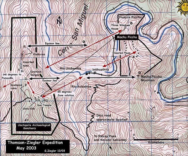
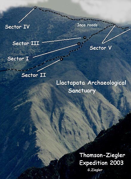
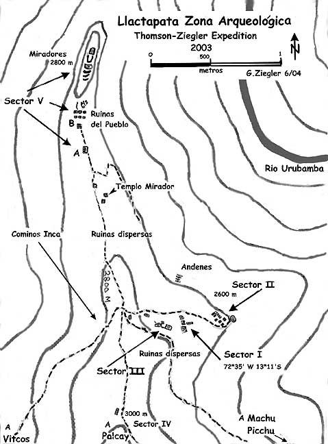
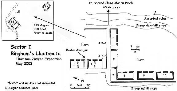
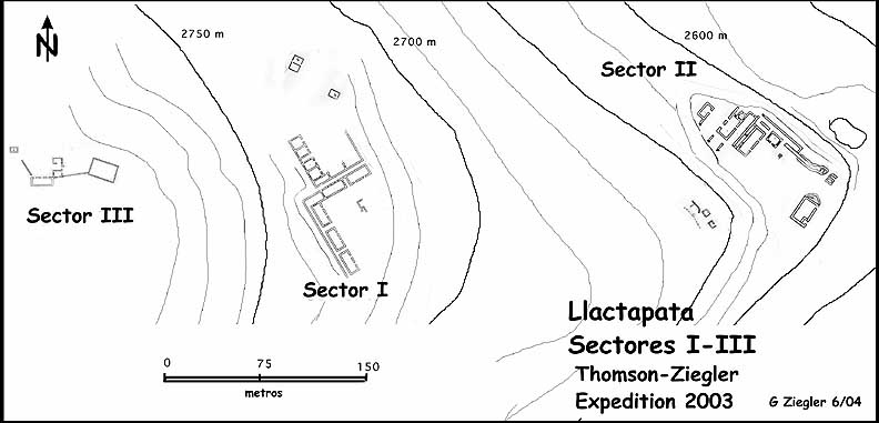
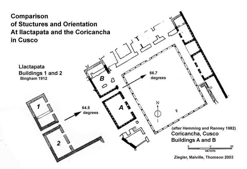
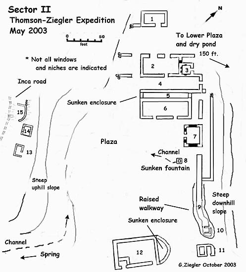
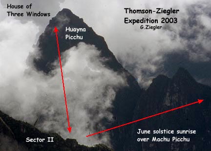
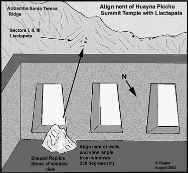
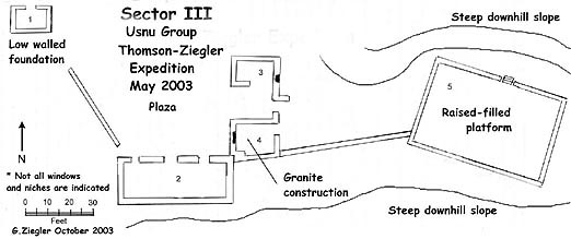
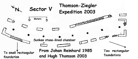
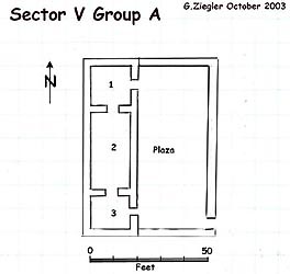
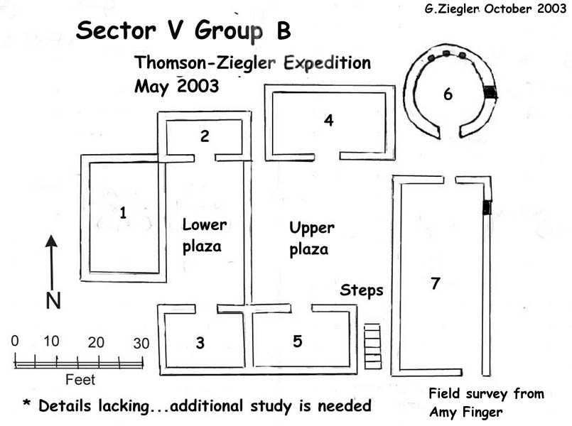
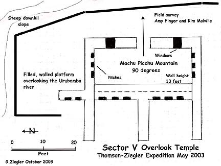